1934
Maker: George Annand.
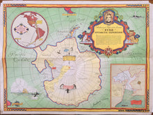
Printed-color pictorial map of Antarctica and the South Pole by George Annand, printed in 1934. The cartouche explains the "notable feat in radio history" that this map was created to commemorate- live radio broadcasts from the expedition "as it is being lived-- from the very lips of the men themselves." This map was subsidized by Grape-Nuts. The map features Antarctica showing the explored and unexplored areas with penguins, whales, bits of New Zealand and South America for reference, and two inset maps. The upper inset map shows the route of Byrd's expedition and the radio waves that will be broadcast from Little America to Buenos Aires to New York and then to the rest of the US. The lower inset map shows the Bay of Whales with a detail map of Little America. This map comes with the original envelope that it was sent in by General Foods company to a customer. Good antique condition overall with some pin holes and damage at corners, very slight seam separations on right and left seams, and mild wear along the folds. Approx. 17 x 23 inches to the neatline.
Item Number: POL013


