Genuine Antique Printed Color Pictorial Map
1926
Maker: Shurtleff & McMillin.
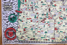
Antique printed color pictorial map of New Hampshire, designed, drawn, and published by Elizabeth Shurtleff and Helen McMillin. The decorative border of this map is filled with the seals/coats of arms of various New Hampshire cities and universities. The map itself is filled with illustrated historical details, references to local jokes/stories, and mainly shows illustrated figures doing various activities, often with comical captions. The small bit of ocean is filled with ships, a sea monster, and a terrified swimmer! With folds, as issued. This map has been rebacked and is in very good overall antique condition with some minor wrinkling/soiling of the outermost edges. Measures approximately 33.25" x 23.25" (H x W) to the outer edges of the decorative border. **NOTE- because this map requires extra insurance for shipping, an additional charge will appear on your card after your original purchase. If you would like to know what that charge will be, please contact us.**
Item Number: NHA403


