Current hours: 10am to 5pm Monday through Saturday. 12pm to 5pm Sundays. IMPORTANT PLEASE NOTE: We have become aware that some of our photos have been stolen by other websites. Our maps are only available at our website www.mapsofantiquity.com or at our store!

Framed-Genuine-Antique-Printed-Color-Pictorial-Map-An-Historical-and-Pictorial-Map-of-Boston-Harbor-and-Massachusetts-Bay-including-Cape-Cod-and-Cape-Ann-1941-Edward-Rowe-Snow-Maps-Of-Antiquity
  • Load image into Gallery viewer, Framed-Genuine-Antique-Printed-Color-Pictorial-Map-An-Historical-and-Pictorial-Map-of-Boston-Harbor-and-Massachusetts-Bay-including-Cape-Cod-and-Cape-Ann-1941-Edward-Rowe-Snow-Maps-Of-Antiquity
  • Load image into Gallery viewer, Framed-Genuine-Antique-Printed-Color-Pictorial-Map-An-Historical-and-Pictorial-Map-of-Boston-Harbor-and-Massachusetts-Bay-including-Cape-Cod-and-Cape-Ann-1941-Edward-Rowe-Snow-Maps-Of-Antiquity
  • Load image into Gallery viewer, Framed-Genuine-Antique-Printed-Color-Pictorial-Map-An-Historical-and-Pictorial-Map-of-Boston-Harbor-and-Massachusetts-Bay-including-Cape-Cod-and-Cape-Ann-1941-Edward-Rowe-Snow-Maps-Of-Antiquity

1941 - An Historical and Pictorial Map of Boston Harbor and Massachusetts Bay including Cape Cod and Cape Ann - Antique Map

Regular price
$125.00
Sale price
$125.00
Regular price
Sold out
Unit price
per 
Shipping calculated at checkout.

Item number: MAS2238
Framed Genuine Antique Printed Color Pictorial Map

1941

Maker: Edward Rowe Snow


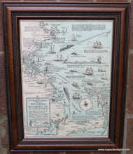
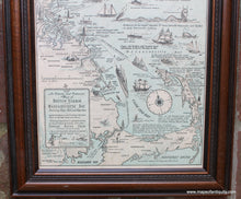
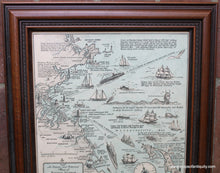
Antique printed color map by Edward Rowe Snow, 1941. This pictorial map shows the coastline from Cape Ann to Cape Cod including Boston and Plymouth Harbors with small illustrations and text throughout. Includes notable buildings, light houses, shipwrecks, ships, a sea monster, and more. Very good condition, framed. Folds are only barely visible. We have not taken this map out of the framing and do not know if the framing is archival. Approx. 15 x 11.25 inches to the neatline. Overall dimensions including frame are approx. 19.5 x 15.5 inches. Additional cost to ship framed map may be required- if you would like to know the total cost of shipping please contact us.


Item Number: MAS2238