Current hours: 10am to 5pm Tuesday through Saturday. We are closed Sundays and Mondays for the Winter. Proud to be a SMALL, LOCAL, CAPE COD BUSINESS! Maps of Antiquity is in its 38th year! Our maps are only available at our website www.mapsofantiquity.com or at our store!

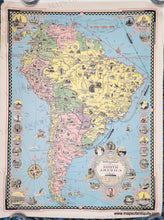
1942 - Moore-McCormack Lines Pictorial Map of South America, designed, drawn and published by Ernest Dudley Chase - Antique Map
  • Load image into Gallery viewer, 1942 - Moore-McCormack Lines Pictorial Map of South America, designed, drawn and published by Ernest Dudley Chase - Antique Map
  • Load image into Gallery viewer, 1942 - Moore-McCormack Lines Pictorial Map of South America, designed, drawn and published by Ernest Dudley Chase - Antique Map
  • Load image into Gallery viewer, 1942 - Moore-McCormack Lines Pictorial Map of South America, designed, drawn and published by Ernest Dudley Chase - Antique Map

1942 - Moore-McCormack Lines Pictorial Map of South America, designed, drawn and published by Ernest Dudley Chase - Antique Map

Regular price
$295.00
Sale price
$295.00
Regular price
Sold out
Unit price
per 
Shipping calculated at checkout.
 More payment options

Pickup available at 1409 MAIN ST, CHATHAM MA

Usually ready in 24 hours

Item number: SAM343

Genuine Antique Colored Map

1942

Maker: Ernest Dudley Chase.


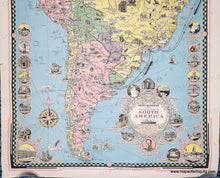
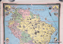
Illustrated antique pictorial map of South America by Ernest Dudley Chase, of South America during World War II, with elaborate cartouche featuring wrought iron detailing and highlighting South American revolutionary hero Simon Bolivar, includes dozens of architectural, natural, and commercial images and descriptions. This map was originally titled "The Good Neighbor Pictorial Map of South America" in reference to President Roosevelt's "good neighbor policy" of 1933, but this map was reissued later for the Moore-McCormack company to show their routes. From 1938 Moore-McCormack ran the "Good Neighbor Fleet" liners Uruguay, Brazil and Argentina between New York and the east coast of South America. The ships were taken into US Navy service during World War 2, then continued their service between NY and South America from 1948-1954. Good overall antique condition with some stains and creasing/wear at the paper edges, especially the upper left corner and left side. Measures approx. 27 x 20 inches. 

Genuine Antique Map from 1942

Item Number: SAM343