Current hours: 10am to 5pm Monday through Saturday. 12pm to 5pm Sundays. IMPORTANT PLEASE NOTE: We have become aware that some of our photos have been stolen by other websites. Our maps are only available at our website www.mapsofantiquity.com or at our store!

Genuine-Antique-Map-A-Map-about-Trout-Fishing-1920s-John-Held-Jr--Maps-Of-Antiquity
1929 - A Map about Trout Fishing - Antique Map
  • Load image into Gallery viewer, Genuine-Antique-Map-A-Map-about-Trout-Fishing-1920s-John-Held-Jr--Maps-Of-Antiquity
  • Load image into Gallery viewer, 1929 - A Map about Trout Fishing - Antique Map

1929 - A Map about Trout Fishing - Antique Map

Regular price
$85.00
Sale price
$85.00
Regular price
Sold out
Unit price
per 
Shipping calculated at checkout.

Item number: OTH419
Genuine Antique Map

1929

Maker: John Held Jr.


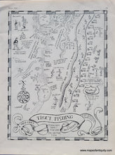
Humorous antique map of an imaginary trout fishing location by John Held Jr. This landscape features scenes familiar to any fishing enthusiast, including a busy opening day, secret streams full of speckled beauties, and some good old fish stories. As the map says, "It isn't so much what you catch, it's the doing of it." This page was published in The Sportsman, April 1929. Would make a great gift! Very good antique condition, printed on slightly shiny paper. Measures approx. 13 x 10 inches to the paper edges.


Item Number: OTH419