1933
Maker: Arthur Moody / Missouri State Highway Commission.
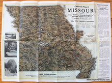
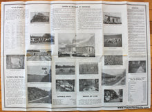
Antique printed color pictorial map of Missouri from a painting by Arthur Moody, published by the Missouri State Highway Commission in 1933. Shows state highways, state parks, rivers and streams, and county seats. From the Century of Progress Issue commemorating the 1933 Chicago Exposition. with scenic photographs on the left side and "Salient facts about Missouri's state highway system" on the right. Additional information is printed on the back, featuring topics like Famous Old Trails, Springs, and State Parks, with many more scenic photographs. Overall good to very good condition with folds as issued. Map has a stain where the state elected officials names are and a small seam separation at two of the fold intersections. Approx. 18.75 x 24 inches to the neatline. Sheet measures approx. 20 x 28 inches overall.
Item Number: MWE401


