Current hours: 10am to 5pm Tuesday through Saturday. We are closed Sundays and Mondays for the Winter. Proud to be a SMALL, LOCAL, CAPE COD BUSINESS! Maps of Antiquity is in its 38th year! Our maps are only available at our website www.mapsofantiquity.com or at our store!

Genuine-Antique-Map-Pictorial-Map-of-the-Province-of-Manitoba-Canada--c.-1948-Department-of-Mines-&-Natural-Resources-Survey-Branch-Maps-Of-Antiquity-1800s-19th-century
1948 - Pictorial Map Of The Province Manitoba Antique Genuine
  • Load image into Gallery viewer, Genuine-Antique-Map-Pictorial-Map-of-the-Province-of-Manitoba-Canada--c.-1948-Department-of-Mines-&-Natural-Resources-Survey-Branch-Maps-Of-Antiquity-1800s-19th-century
  • Load image into Gallery viewer, 1948 - Pictorial Map Of The Province Manitoba Antique Genuine
  • Load image into Gallery viewer, 1948 - Pictorial Map Of The Province Manitoba Antique Genuine

1948 - Pictorial Map of the Province of Manitoba - Antique Map

Regular price
$95.00
Sale price
$95.00
Regular price
Sold out
Unit price
per 
Shipping calculated at checkout.
 More payment options

Pickup available at 1409 MAIN ST, CHATHAM MA

Usually ready in 24 hours

Item number: CAN354
Genuine Antique Map

c. 1948

Maker: Department of Mines & Natural Resources, Survey Branch.

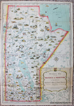
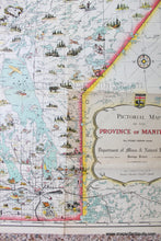
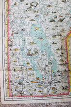
Antique pictorial map of Manitoba, Canada, published by the Department of Mines & Natural Resources, Survey Branch, c. 1948. This map features illustrations throughout depicting local flora, fauna, outdoor activities such as hunting & fishing, airplanes, buildings, and more. Good antique condition withh folds as issued and wear along the fold lines. Some small separations at fold intersections. Measures approx. 27 x 18.5 inches.

Item Number: CAN354