Current hours: 10am to 5pm Monday through Saturday. 12pm to 5pm Sundays. IMPORTANT PLEASE NOTE: We have become aware that some of our photos have been stolen by other websites. Our maps are only available at our website www.mapsofantiquity.com or at our store!

Antique-Map-Pony-Express-Route-Pictorial-Historic-History-Pioneer-Trails-Association-Centennial-W.-H.-Jackson-1961-Maps-of-Antiquity
  • Load image into Gallery viewer, Antique-Map-Pony-Express-Route-Pictorial-Historic-History-Pioneer-Trails-Association-Centennial-W.-H.-Jackson-1961-Maps-of-Antiquity
  • Load image into Gallery viewer, Antique-Map-Pony-Express-Route-Pictorial-Historic-History-Pioneer-Trails-Association-Centennial-W.-H.-Jackson-1961-Maps-of-Antiquity
  • Load image into Gallery viewer, Antique-Map-Pony-Express-Route-Pictorial-Historic-History-Pioneer-Trails-Association-Centennial-W.-H.-Jackson-1961-Maps-of-Antiquity

1951 - Pony Express Route (April 3, 1860 - October 24, 1861.) - Antique Pictorial Map

Regular price
$165.00
Sale price
$165.00
Regular price
Sold out
Unit price
per 
Shipping calculated at checkout.

Item number: WES306
Genuine Antique Printed Color Pictorial Map

1951

Maker: William Henry Jackson and Howard Roscoe Driggs


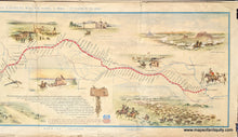
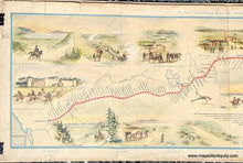
Antique printed color pictorial map showing the historic Pony Express Route, between St. Joseph, Missouri and Sacramento California, and listing each stop that was made along the route. The trail travels through the present-day states of Missouri, Kansas, Nebraska, Colorado, Wyoming, Utah, Nevada, and California. Surrounding the map are illustrations showing picturesque scenes of the Old West. At the bottom of the map is a quote from Howard R. Driggs regarding the historical significance of the Pony Express. Map is by William Henry Jackson and Howard Roscoe Driggs, and this is the first edition of this map, published in 1951 (a later edition was published in 1960 by the American Pioneer Trails Assoc.). Fair to  good overall antique condition with toning, tears, and other signs of age, most of which can be hidden under a mat when framing. Some vertical fold lines. Measures approximately 8.5" x 28.5" (H x W) to the neatline and page measures 10.25" x 30" in its entirety.  


Item Number: WES306