Winter hours: Tuesday - Saturday 10am to 5pm. Close Sundays and Mondays until May. We appreciate your business!

Antique-Printed-Color-Pictorial-Folding-Map-Southwest-Portion-of-San-Bernardino-County-1935-San-Bernardino-County-Chamber-of-Commerce-West-California-1800s-19th-century-Maps-of-Antiquity
1935 - Southwest Portion of San Bernardino County - Antique Pictorial Map
  • Load image into Gallery viewer, Antique-Printed-Color-Pictorial-Folding-Map-Southwest-Portion-of-San-Bernardino-County-1935-San-Bernardino-County-Chamber-of-Commerce-West-California-1800s-19th-century-Maps-of-Antiquity
  • Load image into Gallery viewer, 1935 - Southwest Portion of San Bernardino County - Antique Pictorial Map

1935 - Southwest Portion of San Bernardino County - Antique Pictorial Map

Regular price
$125.00
Sale price
$125.00
Regular price
Sold out
Unit price
per 
Shipping calculated at checkout.

Item number: WES357
Genuine Antique Printed Color Pictorial Folding Map

1935

Maker: San Bernardino County Chamber of Commerce.

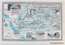
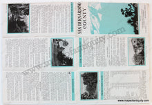
Antique printed color pictorial folding map of a southwestern portion of San Bernardino County, California. Includes Lake Arrowhead, Big Bear Lake, San Gorgonio Mountain, etc. Features illustrated vignettes showing local views/points of interest (Winter Sports, Citrus Packing in Upland, Poultry in Fontana, Highland Citrus Crops, Euclid Avenue in Ontario, Chapel at Redlands University, The Madonna of the Trail in Upland, etc.) Also includes an illustrated map with the area's relative location to Los Angeles. With folds, as issued. Good to Very good overall antique condition with mild wrinkling and edge wear, as well as some extra wear at the fold intersections. Measures approximately 11.25" x 17.25" (H x W) to the outer edge of the decorative border.

Item Number: WES357