Current hours: 10am to 5pm Monday through Saturday. 12pm to 5pm Sundays. IMPORTANT PLEASE NOTE: We have become aware that some of our photos have been stolen by other websites. Our maps are only available at our website www.mapsofantiquity.com or at our store!

Antique-Map-The-Island-of-Hawaii-Ruth-Taylor-White-1930-Pictorial-Maps-Of-Antiquity
1930 - The Island of Hawaii - Antique Pictorial Map
  • Load image into Gallery viewer, Antique-Map-The-Island-of-Hawaii-Ruth-Taylor-White-1930-Pictorial-Maps-Of-Antiquity
  • Load image into Gallery viewer, 1930 - The Island of Hawaii - Antique Pictorial Map
  • Load image into Gallery viewer, 1930 - The Island of Hawaii - Antique Pictorial Map

1930 - The Island of Hawaii - Antique Pictorial Map

Regular price
$150.00
Sale price
$150.00
Regular price
Sold out
Unit price
per 
Shipping calculated at checkout.

Item number: WES312
Genuine Antique Pictorial Map

1930

Maker: Ruth Taylor White.

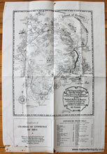
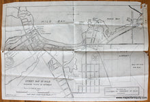
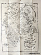
Uncolored antique pictorial map of the Big Island of Hawaii by Ruth Taylor White, and published by the Chamber of Commerce of Hilo, 1930. This map features illustrations of visitors and locals participating in a variety of activities, such as hiking, surfing, fishing, sledding, golfing, and more. Also shows the volcanic flows with the years they occurred. Verso has a street map of Hilo with points of interest by B.D.Chilson and the W.P.A. of Hilo. Good to very good condition with some damage at edges but the main map is undamaged. Pictorial map measures approx. 14.75 x 11.25 inches to the neatline. Hilo street map is approx. 13.25 x 20 inches to the neatline. Priced as-is.

Item Number: WES312