Current hours: 10am to 5pm Monday through Saturday. 12pm to 5pm Sundays. IMPORTANT PLEASE NOTE: We have become aware that some of our photos have been stolen by other websites. Our maps are only available at our website www.mapsofantiquity.com or at our store!

Antique-Pictorial-Map-The-Valley-of-Parks-in-Kentucky's-Laurel-Land-c.-1950-Midwest-Kentucky-1800s-19th-century-Maps-of-Antiquity
1950 - The Valley of Parks in Kentucky's Laurel Land - Antique Pictorial Map
  • Load image into Gallery viewer, Antique-Pictorial-Map-The-Valley-of-Parks-in-Kentucky's-Laurel-Land-c.-1950-Midwest-Kentucky-1800s-19th-century-Maps-of-Antiquity
  • Load image into Gallery viewer, 1950 - The Valley of Parks in Kentucky's Laurel Land - Antique Pictorial Map

1950 - The Valley of Parks in Kentucky's Laurel Land - Antique Pictorial Map

Regular price
$50.00
Sale price
$50.00
Regular price
Sold out
Unit price
per 
Shipping calculated at checkout.

Item number: MWE415
Genuine Antique Pictorial Map

c. 1950

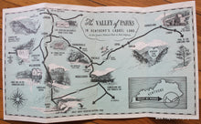
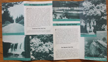
Antique printed color pictorial map of the Valley of Parks in Kentucky, c. 1950. Includes Cumberland Falls State Park, Cumberland National Forest, Levi Jackson Wilderness Road State Park, Dr. Thomas Walker State Park, Pine Mountain State Park, Norris Dam, Cumberland Gap and Pinnacle Mountain, the Rhododendron Trail, and more. Verso consists of tourist information and photos featuring the Cumberland Falls and the Mountain Laurel Festival, which is a tradition that continues to this day! Very good condition with folds as issued and a few staple holes in the center fold. Sheet measures approx. 9 x 15.75 inches.

 Item Number: MWE415