Current hours: 10am to 5pm Monday through Saturday. 12pm to 5pm Sundays. IMPORTANT PLEASE NOTE: We have become aware that some of our photos have been stolen by other websites. Our maps are only available at our website www.mapsofantiquity.com or at our store!

Genuine-Antique-Pictorial-Map-A-Pictorial-Map-of-the-Hawaiian-Islands,-The-United-States'-Fiftieth-State-1960-Ernest-Dudley-Chase-Maps-Of-Antiquity
  • Load image into Gallery viewer, Genuine-Antique-Pictorial-Map-A-Pictorial-Map-of-the-Hawaiian-Islands,-The-United-States'-Fiftieth-State-1960-Ernest-Dudley-Chase-Maps-Of-Antiquity
  • Load image into Gallery viewer, Genuine-Antique-Pictorial-Map-A-Pictorial-Map-of-the-Hawaiian-Islands,-The-United-States'-Fiftieth-State-1960-Ernest-Dudley-Chase-Maps-Of-Antiquity
  • Load image into Gallery viewer, Genuine-Antique-Pictorial-Map-A-Pictorial-Map-of-the-Hawaiian-Islands,-The-United-States'-Fiftieth-State-1960-Ernest-Dudley-Chase-Maps-Of-Antiquity
  • Load image into Gallery viewer, Genuine-Antique-Pictorial-Map-A-Pictorial-Map-of-the-Hawaiian-Islands,-The-United-States'-Fiftieth-State-1960-Ernest-Dudley-Chase-Maps-Of-Antiquity

1960 - A Pictorial Map of the Hawaiian Islands, The United States' Fiftieth State - Antique Pictorial Map

Regular price
$750.00
Sale price
$750.00
Regular price
Sold out
Unit price
per 
Shipping calculated at checkout.

Item number: WES433
Genuine Antique Pictorial Map

1960

Maker: Ernest Dudley Chase

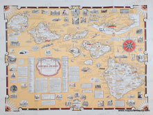
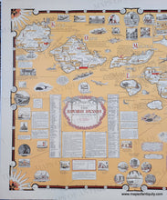
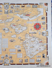
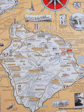
Antique printed color map of Hawaii by Ernest Dudley Chase, copyright 1960. Hawaii became a state on August 21, 1959 and this map was created as a commemorative map, with history and data up to 1959. Illustrations throughout of volcanoes, flora, fauna, and interesting places. Additional illustrations and scenes decorate the ocean and edges, along with interesting facts and historical notes. Detailed map in warm tropical colors. Inset at upper right shows the Honolulu area with surfers. Very good condition with folds as issued. Some wear along the fold lines. Measures approx. 22 x 29 inches to the paper edges.

Item Number: WES433