Current hours: 10am to 5pm Monday through Saturday. Closed on Sundays. IMPORTANT PLEASE NOTE: We have become aware that some of our photos have been stolen by other websites. Our maps are only available at our website www.mapsofantiquity.com or at our store!

1879 - Double-sided sheet with three maps: Nantasket Beach/Hull/Downer Landing (MA) - Antique Map
  • Load image into Gallery viewer, 1879 - Double-sided sheet with three maps: Nantasket Beach/Hull/Downer Landing (MA) - Antique Map
  • Load image into Gallery viewer, 1879 - Double-sided sheet with three maps: Nantasket Beach/Hull/Downer Landing (MA) - Antique Map
  • Load image into Gallery viewer, 1879 - Double-sided sheet with three maps: Nantasket Beach/Hull/Downer Landing (MA) - Antique Map

1879 - Double-sided sheet with three maps: Nantasket Beach/Hull/Downer Landing (MA) - Antique Map

Regular price
$150.00
Sale price
$150.00
Regular price
Sold out
Unit price
per 
Shipping calculated at checkout.

Item number: MAS1495

Genuine Antique Hand Colored Map

1879

Maker: Walker.


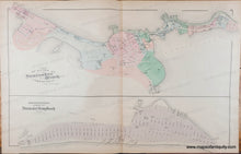
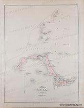
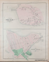
Antique page of maps from the Atlas of Plymouth County, MA, 1879, by Walker. Larger centerfold map showing Plan of Lands at Nantasket Beach and George Wheatland's Lands at Nantasket Long Beach, including resort hotels, beachside cafes and bathhouses, steamboat wharves. With property owners, businesses, named streets. The back sides of the page display the Town of Hull and several harbor islands on one side and the Village of Hull and Downer Landing on the other side. Good antique condition with minor stains, centerfold map measures approx. 16 x 25.5 inches.

Genuine Antique Map from 1879

Item Number: MAS1495