Antique-Hand-Colored-Map-Plan-of-New-York-Island-and-part-of-Long-Island-Shewing-the-Position-of-the-American-and-British-Armies-before-at-and-after-the-Engagement-on-the-Heights-August-27th-1776--United-States-New-York-1832-Marshall-Maps-Of-Antiquity-1800s-19th-century
  • Load image into Gallery viewer, Antique-Hand-Colored-Map-Plan-of-New-York-Island-and-part-of-Long-Island-Shewing-the-Position-of-the-American-and-British-Armies-before-at-and-after-the-Engagement-on-the-Heights-August-27th-1776--United-States-New-York-1832-Marshall-Maps-Of-Antiquity-1800s-19th-century
  • Load image into Gallery viewer, Antique-Hand-Colored-Map-Plan-of-New-York-Island-and-part-of-Long-Island-Shewing-the-Position-of-the-American-and-British-Armies-before-at-and-after-the-Engagement-on-the-Heights-August-27th-1776--United-States-New-York-1832-Marshall-Maps-Of-Antiquity-1800s-19th-century

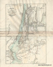
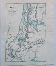
c. 1827 or 1832 - Plan of New York Island and part of Long Island ... August 27th 1776 - Antique Map

Regular price
$250.00
Sale price
$250.00
Regular price
Sold out
Unit price
per 
Shipping calculated at checkout.

Item number: NYO906
Genuine Antique Hand Colored Map

c. 1827 or 1832

Maker: Marshall.

 Plan of New York Island and part of Long Island Shewing the Position of the American and British Armies before, at, and after the Engagement on the Heights August 27th, 1776

Antique hand colored map of the area around Manhattan, New York showing important locations in the Revolutionary War, especially the Battle of Long Island, also known as the Battle of Brooklyn and the Battle of Brooklyn Heights. From the atlas to accompany Marshall's "The Life of Washington". Shows rivers, water bodies, landforms, towns, forts, and roads. With center fold as issued in book.

1832 edition: Good condition with minor spots, and some discoloration and wrinkling at the center along the fold.

c. 1827 edition: Very good condition with slight separation along fold at sides. This map has been cleaned and the red color was partially lifted off.

Measures approx.  9.25 x 6.5 inches.


Item Number: NYO906