UNFRAMED MAPS should be ordered PRIOR TO Thursday, DECEMBER 19th for arrival by December 25th (December 13th deadline for Hawaii). We are past the deadline for orders with custom framing unless you will be picking up. Current hours: 10am to 5pm Monday through Saturday. 12pm to 5pm Sundays. IMPORTANT PLEASE NOTE: We have become aware that some of our photos have been stolen by other websites. Our maps are only available at our website www.mapsofantiquity.com or at our store!

Framed-Genuine-Antique-Map-Americae-Mappa-generalis-Secundum-legimitas-projectionis-Stereiographiae-regulas-1746-Homann-Heirs-Maps-Of-Antiquity
Framed-Genuine-Antique-Map-Americae-Mappa-generalis-Secundum-legimitas-projectionis-Stereiographiae-regulas…-1746-Homann-Heirs-Maps-Of-Antiquity
  • Load image into Gallery viewer, Framed-Genuine-Antique-Map-Americae-Mappa-generalis-Secundum-legimitas-projectionis-Stereiographiae-regulas-1746-Homann-Heirs-Maps-Of-Antiquity
  • Load image into Gallery viewer, Framed-Genuine-Antique-Map-Americae-Mappa-generalis-Secundum-legimitas-projectionis-Stereiographiae-regulas…-1746-Homann-Heirs-Maps-Of-Antiquity
  • Load image into Gallery viewer, Framed-Genuine-Antique-Map-Americae-Mappa-generalis-Secundum-legimitas-projectionis-Stereiographiae-regulas…-1746-Homann-Heirs-Maps-Of-Antiquity
  • Load image into Gallery viewer, Framed-Genuine-Antique-Map-Americae-Mappa-generalis-Secundum-legimitas-projectionis-Stereiographiae-regulas…-1746-Homann-Heirs-Maps-Of-Antiquity

1746 - Americae Mappa generalis Secundum legimitas projectionis Stereiographiae regulas... - Antique Map

Regular price
$825.00
Sale price
$825.00
Regular price
Sold out
Unit price
per 
Shipping calculated at checkout.

Item number: WOR367
Framed Genuine Antique Map

1746

Maker: Homann Heirs

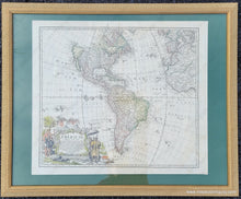
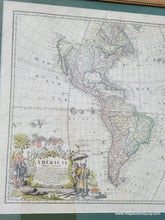
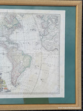
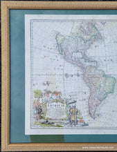
Antique hand colored map of North and South America dated 1746, likly from Homann's Atlas Scholasticus by Homann Heirs. This map reflects many important changes in geographic knowledge. There is notably more information in the interior of North America thanks to the Jesuits and along the coast thanks to the English and Dutch. Dotted lines delineate the claims of the French, Spanish, British, including Florida Hispanica, Louisiana, California, Nova Britania, Mexicum Novum, etc. The northwest was still unknown and the prominent label of Quivira, a legendary city of gold sits just above New Albion and California. The Rocky Mountains are not yet understood. South America has been reshaped thanks to new information and is also divided into regions, including Terra Firma, Regiones Amazona, and Peruvia Regnum. Text is in Latin. Handsome decorative cartouche includes palm trees, native peoples, and exploding volcanoes. This is an important map that reflects a time when understanding of the Americas was beginning to approach our modern understanding of the land forms. Framing is somewhat recent and matting appears to be acid-free, which suggests archival framing. Matting seems to be somewhat crudely done and it is not equal widths on all sides. Measures approx. 18 x 20.25 inches to the border line and 25 x 30 inches to the frame edges. **NOTE- because this map requires extra insurance for shipping, an additional charge will appear on your card after your original purchase. If you would like to know what that charge will be, please contact us. If you would prefer to have the map shipped unframed, which will save on shipping, please let us know (price does not change if map is sold without the framing)**

Item Number: WOR367