Winter hours: Tuesday - Saturday 10am to 5pm. Close Sundays and Mondays until May. We appreciate your business!

Antique-Printed-Color-Map-Sumatra-verso:-Birds-Eye-View-of-The-Holy-Land-Asia-Middle-East-&-Holy-Land-Southeast-Asia-&-Indonesia-1894-Cram-Maps-Of-Antiquity
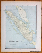
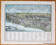
1894 - Sumatra, verso: Birds-Eye-View of The Holy Land - Antique Map
  • Load image into Gallery viewer, Antique-Printed-Color-Map-Sumatra-verso:-Birds-Eye-View-of-The-Holy-Land-Asia-Middle-East-&-Holy-Land-Southeast-Asia-&-Indonesia-1894-Cram-Maps-Of-Antiquity
  • Load image into Gallery viewer, 1894 - Sumatra, verso: Birds-Eye-View of The Holy Land - Antique Map
  • Load image into Gallery viewer, 1894 - Sumatra, verso: Birds-Eye-View of The Holy Land - Antique Map

1894 - Sumatra, verso: Birds-Eye-View of The Holy Land - Antique Map

Regular price
$50.00
Sale price
$50.00
Regular price
Sold out
Unit price
per 
Shipping calculated at checkout.

Item number: ASI328
Genuine Antique Printed Color Map

1894

Maker: Cram.

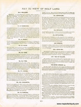
Antique printed color map of Sumatra (Recto). Verso: Bird's eye view map of The Holy Land. Features a reference to the points of interest, including a list of mountains with their respective heights. The sheet "Key to View of Holy Land" will be included as a photocopy with this map because it is printed on the verso of a different map. Very good condition with some slight toning at the edges of the page and a very small tear at one edge. By Cram, in The Standard Atlas and Gazetteer of The World, 1894. Recto Map: Approximately 12.25" x 8.75" to the neatline. Verso Map: Approx. 9.75" x 12.25" to the neatline.

Item Number: ASI328