1920s
Maker: Orell Fussli
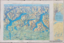
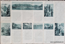
Antique bird's-eye view map of the area around Lugano, Switzerland, on the border of Italy. This map is undated but may be from the 1920s, based on the clothing in one of the photographs and the limited automobile routes, especially compared with the extensive train routes. There is also a bit of text crossed out and the word passport filled in, which may be related to the UN's passport regulations of the 1920s. This is only a guess, however, and the map may be more recent than we surmise. This map includes Lago Maggiore, Lago di Como, many smaller towns and villages, and the Alps in the distance with the heights of some of the mountains. On the right side are two small er maps, one showing routes around the area, and the other showing Lugano and environs. On the back is tourism information and photographs. Very good condition with original color and folds as issued. Measures approx. 15.75 x 23.5 inches to the paper edges.
Item Number: EUR3160


