Current hours: 10am to 5pm Monday through Saturday. 12pm to 5pm Sundays. IMPORTANT PLEASE NOTE: We have become aware that some of our photos have been stolen by other websites. Our maps are only available at our website www.mapsofantiquity.com or at our store!

Antique-Uncolored-Map-A-Correct-Draught-of-the-River-Thames-from-its-Spring-in-Gloucester-Shireto-its-Influx-into-the-Seawith-a-Table-of-all-the-BridgesLocksWears-&c.-thereupon-The-Tolls-payable-at-each-and-their-distance-by-Water-from-each-other.-Exhibiting-also-the-Coutries-adjacent-&c.-The-whole-carefully-Compiled-from-modern-Surveys-&-Authentic-Intelligence.-1775-Bowen/London-Magazine-England-1700s-18th-century-Maps-of-Antiquity
1775 - A Correct Draught of the River Thames - Antique Map
  • Load image into Gallery viewer, Antique-Uncolored-Map-A-Correct-Draught-of-the-River-Thames-from-its-Spring-in-Gloucester-Shireto-its-Influx-into-the-Seawith-a-Table-of-all-the-BridgesLocksWears-&c.-thereupon-The-Tolls-payable-at-each-and-their-distance-by-Water-from-each-other.-Exhibiting-also-the-Coutries-adjacent-&c.-The-whole-carefully-Compiled-from-modern-Surveys-&-Authentic-Intelligence.-1775-Bowen/London-Magazine-England-1700s-18th-century-Maps-of-Antiquity
  • Load image into Gallery viewer, 1775 - A Correct Draught of the River Thames - Antique Map
  • Load image into Gallery viewer, 1775 - A Correct Draught of the River Thames - Antique Map

1775 - A Correct Draught of the River Thames - Antique Map

Regular price
$325.00
Sale price
$325.00
Regular price
Sold out
Unit price
per 
Shipping calculated at checkout.

Item number: EUR2581
Genuine Antique Uncolored Map

1775

Maker: Bowen/London Magazine.

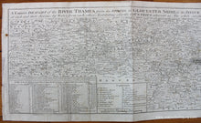
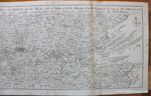
Rare antique map of the course of the Thames River, by Thomas Bowen and published in the London Magazine in 1775. A Correct Draught of the River Thames from its Spring in Gloucester Shire, to its Influx into the Sea, with a Table of all the Bridges, Locks, Wears &c. thereupon The Tolls payable at each and their distance by Water from each other. Exhibiting also the Countries adjacent &c. The whole carefully Compiled from modern Surveys & Authentic Intelligence. Very detailed, showing counties, towns, villages, roads, waterways, distances, notable sites, and a table related to the tolls. Very little information about this map is available. Bowles produced a similar map around this time (online sources suggest Bowles created one in 1774 and an updated version in 1793, although I cannot find any examples of a 1774 version). In 1818 a reader wrote to the Monthly Magazine and said that they used this map on a pleasure excursion on the Thames and that the experience was so enjoyable that they went again from another location. This map is in good condition overall with some stains in the margins, mild foxing, and a repaired seam separation on the right side with some image loss. Measures approx. 7.25 x 24 inches to the neatline.

Item Number: EUR2581