1927
Maker: NY New Haven and Hartford Railroad Co..
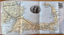
Antique printed color railroad map of Cape Cod showing the route of the New York, New Haven, and Hartford Railroad, which had stops throughout the Cape. Published in 1927 by the New York, New Haven, and Hartford Railroad Co. The printed photograph at the center shows two children in the water. This map shows town boundaries, light houses, village centers, and more. Very good condition with folds as issued. Map is pprox. 7 3/4 x 15 inches to the neatline. The piece includes a book written by Walter Prichard Eaton called "Cape Cod - A Plain Tale of the Lure of the Old Colony Country." It includes descriptions and photographs of towns throughout the Cape. Map is attached at the back of this booklet.
Item Number: MAS511B


