1848
Maker: Robert Mills
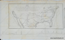
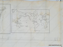
Antique map of part of the United states by Robert Mills, 1848. The map on the left says "Map of the Country between the Atlantic & Pacific Oceans Included within the latitudes 25 & 42 & the longitudes 75 & 123 West, shewing the proposed route of a Rail Road from the Mississippi Valley to the Ports of St Diego, Monterey, & St Francisco on the Pacific coast also the connection of this Road with those of the Atlantic States leading West as far as the Mississippi, compiled from the Reconnoissances of Col. Fremont, Lt. Col. Emory, Dr. Wislizenus & others." The chart at the bottom shows the elevation profile of the route and is labeled "Barometric Profile of the route across the Prairies between Arkansas & Red Rivers from the Valley of the Mississippi Memphis & St Louis by the Rio del Norte to San Diego on the Pacific." The map in the upper right shows the world on Mercator's projection with the US at center. The text reads "This Map shews the position of our Continent as compared with Europe and Africa on one side and Asia on the other, placing us in the centre of Europe 5000 miles from us, with a population of 250,000,000, and Asia on the other side, about 5000 miles from us, with a population of more than 700,000,000. The Rail Road across our Continent will make us the centre and thoroughfare for both." Good to very good condition with some mild spots/foxing, minor toning at the paper edges, a few slight creases/wrinkles, and some tiny separations at the seam edges. Folds as issued. Measures approx. 12 x 37 inches to the paper edges.
Item Number: USA437


