Current hours: 10am to 5pm Monday through Saturday. Closed on Sundays. IMPORTANT PLEASE NOTE: We have become aware that some of our photos have been stolen by other websites. Our maps are only available at our website www.mapsofantiquity.com or at our store!

Genuine-Antique-Hand-Colored-Map-Double-sided-page-Kentucky-and-Tennessee-verso-Ohio-and-Indiana-1850-Mitchell-Thomas-Cowperthwait-Co--Maps-Of-Antiquity
  • Load image into Gallery viewer, Genuine-Antique-Hand-Colored-Map-Double-sided-page-Kentucky-and-Tennessee-verso-Ohio-and-Indiana-1850-Mitchell-Thomas-Cowperthwait-Co--Maps-Of-Antiquity
  • Load image into Gallery viewer, Genuine-Antique-Hand-Colored-Map-Double-sided-page-Kentucky-and-Tennessee-verso-Ohio-and-Indiana-1850-Mitchell-Thomas-Cowperthwait-Co--Maps-Of-Antiquity

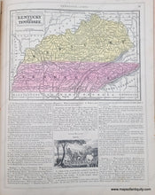
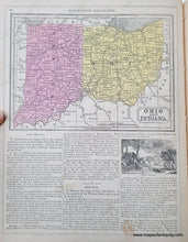
1850 - Double-sided page: Kentucky and Tennessee, verso: Ohio and Indiana - Antique Map

Regular price
$45.00
Sale price
$45.00
Regular price
Sold out
Unit price
per 
Shipping calculated at checkout.

Item number: MWE564
Genuine Antique Hand-Colored Map

1850

Maker: Mitchell/ Thomas, Cowperthwait & Co.

Antique map from Mitchell's Intermediate Geography, by Augustus Mitchell and published by Thomas, Cowperthwait & Co. in 1850. Shows cities, counties, railroads, and some topography. On a page with additional text. Very good antique condition with some tiny spots. KY and TN map measures approx. 5.5 x 8 inches to the neatline. OH and IN map measures approx. 5.75 x 8 inches to the neatline. Total page size is 12.25 x 9.25 inches.

Item Number: MWE564