Pickup available at 1409 MAIN ST, CHATHAM MA
Usually ready in 24 hours
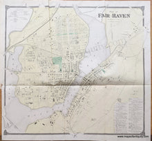
1868 - Plan of Fair Haven, CT - Antique Map
-
1409 MAIN ST, CHATHAM MA
Pickup available, usually ready in 24 hours1409 Main Street
Chatham MA 02633
United States+15089451660
1868
Maker: F.W. Beers
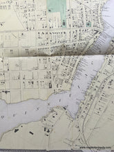
Antique hand colored map, from F.W. Beers' "County Atlas of New Haven", 1868. This is a folding map of Fair Haven, Connecticut, CT, showing named roads, railroads, property owners, schools, public buildings, businesses, churches, cemeteries, and topographical details; includes subscribers' business directory and references to some of the buildings on Grand St. Good condition with some minor spotting, wrinkles, and creases. Printed on light-weight paper that should be simply to flatten. Small tear at left side. Measures approx. 22.25 x 24 inches to the edges of the decorative border.
Item Number: CON421


