Winter hours: Tuesday - Saturday 10am to 5pm. Close Sundays and Mondays until May. We appreciate your business!

Genuine-Antique-Map-A-Map-of-New-England-New-York-New-Jersey-and-Pennsilvanie--1730-Moll-Maps-Of-Antiquity
Genuine-Antique-Map-A-Map-of-New-England-New-York-New-Jersey-and-Pennsilvania-Pensilvania-1730-Moll-Maps-Of-Antiquity
Genuine-Antique-Map-A-Map-of-New-England-New-York-New-Jersey-and-Pennsilvanie--1730-Moll-Maps-Of-Antiquity
  • Load image into Gallery viewer, Genuine-Antique-Map-A-Map-of-New-England-New-York-New-Jersey-and-Pennsilvanie--1730-Moll-Maps-Of-Antiquity
  • Load image into Gallery viewer, Genuine-Antique-Map-A-Map-of-New-England-New-York-New-Jersey-and-Pennsilvania-Pensilvania-1730-Moll-Maps-Of-Antiquity
  • Load image into Gallery viewer, Genuine-Antique-Map-A-Map-of-New-England-New-York-New-Jersey-and-Pennsilvanie--1730-Moll-Maps-Of-Antiquity

1730 - A Map of New England, New York, New Jersey and Pensilvania - Antique Map

Regular price
$2,500.00
Sale price
$2,500.00
Regular price
Sold out
Unit price
per 
Shipping calculated at checkout.

Item number: CSMT116
Genuine Antique Map

1730

Maker: Moll


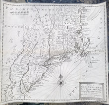
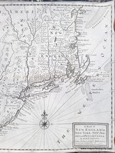
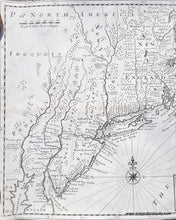
Rare antique map of the Northeast by Moll, 1730. This map was published in David Humphreys's An Historical Account of the Incorporated Society for the Propagation of the Gospel in Foreign Parts. Containing their Foundation, Proceedings, and the Success of their Missionaries in the British Colonies, to the Year 1728. It includes the New England colonies, East and West Jersey stretching quite far north, a tall and skinny New York with a plump Long Island, a squished Cape Cod and oddly-shaped Nantucket (labelled Nantucher on the map) and Martha's Vineyard (labelled Martin's Vineyard on the map). This map is as fascinating and delightful as it is rare. An excellent addition to any map collection. Very good condition with tight margins. May have been restored. Measures approx. 14.25 x 15.25 inches to the neatline.


Item Number: CSMT116