1867
Maker: Bien / US War Dept.
Â
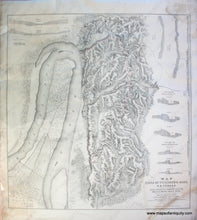
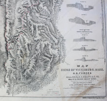
Antique hand-colored Civil War battle map published by the US War Department. Shown on this map is the area around Vicksburg, Mississippi, where an important battle of the American Civil War took place. In May and June of 1863, Maj. Gen. Ulysses S. Grant's armies converged on Vicksburg, investing the city and entrapping a Confederate army under Lt. Gen. John Pemberton. On July 4, Vicksburg surrendered after prolonged siege operations. This was the culmination of one of the most brilliant military campaigns of the war. With the loss of Pemberton's army and this vital stronghold on the Mississippi, the Confederacy was effectively split in half. Grant's successes in the West boosted his reputation, leading ultimately to his appointment as General-in-Chief of the Union armies.(source: nps.gov) This map shows Federal works in blue and Rebel works in red. It includes Cross-sections of Federal and Rebel batteries, as well as profiles of parts of the areas to give us a clear understanding of the topography involved in the battle. This map is dated 1863, although probably published in 1867 and possibly by Bien, although the lithographer is not specifically noted. Informative, rare, and collectible. Good restored condition with some stains. This map has been archivally cleaned, deacidified, and rebacked. It has some repaired paper loss in the margins. Some surface soiling. Measures approx. 29 x 27.5 inches to the neatline. **NOTE- because this map requires extra insurance for shipping, an additional charge will appear on your card after your original purchase. If you would like to know what that charge will be, please contact us.**
Â
Item Number: CIV028


