Current hours: 10am to 5pm Monday through Saturday. Closed on Sundays. IMPORTANT PLEASE NOTE: We have become aware that some of our photos have been stolen by other websites. Our maps are only available at our website www.mapsofantiquity.com or at our store!

Genuine-Map-Alaska-and-Western-Canada-1950s-Kroll-Map-Company-Maps-Of-Antiquity
  • Load image into Gallery viewer, Genuine-Map-Alaska-and-Western-Canada-1950s-Kroll-Map-Company-Maps-Of-Antiquity
  • Load image into Gallery viewer, Genuine-Map-Alaska-and-Western-Canada-1950s-Kroll-Map-Company-Maps-Of-Antiquity
  • Load image into Gallery viewer, Genuine-Map-Alaska-and-Western-Canada-1950s-Kroll-Map-Company-Maps-Of-Antiquity

1950s - Alaska and Western Canada - Antique Map

Regular price
$125.00
Sale price
$125.00
Regular price
Sold out
Unit price
per 
Shipping calculated at checkout.

Item number: WES446
Genuine Map

1950s

Maker: Kroll Map Company


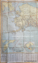
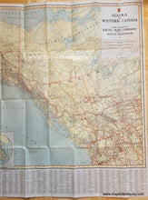
Detailed map of Alaska and Western Canada with Washington and parts of Idaho and Montana. This map was published in the 1950s by the Kroll Map Company, which still exists today. It shows roads, railroads, highways, trails (pack horse or sled), Sled roads (horse or tractor), provincial and state boundaries, cities, towns, proposed highways, parks, time zones, and more. At bottom is an index to towns and places. Inset maps are Kamchatka Peninsula and the Northern Hemisphere. Very good condition with folds as issued, some small wear and tear at paper edges. Measures approx. 28 x 42 inches to the map neatline. Total sheet measurements are 34 x 42.5 inches.


Item Number: WES446