Current hours: 10am to 5pm Tuesday through Saturday. We are closed Sundays and Mondays for the Winter. IMPORTANT PLEASE NOTE: We have become aware that some of our photos have been stolen by other websites. Our maps are only available at our website www.mapsofantiquity.com or at our store!

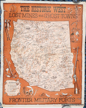
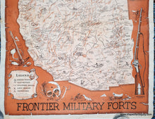
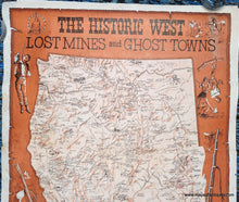
Pictorial map in the style of an old west poster bulletin. Orange-brown color along with black and white. Large map at the center shows the entire western half of the United States with lots of information and some illustrations. The Legend shows Ghost Towns, Old Mines, Military Posts, Lost Mines, and Missions. Dramatic illustrations surround the map including a rifle and a skull with a hole in the forehead.
  • Load image into Gallery viewer, Pictorial map in the style of an old west poster bulletin. Orange-brown color along with black and white. Large map at the center shows the entire western half of the United States with lots of information and some illustrations. The Legend shows Ghost Towns, Old Mines, Military Posts, Lost Mines, and Missions. Dramatic illustrations surround the map including a rifle and a skull with a hole in the forehead.
  • Load image into Gallery viewer, Pictorial map in the style of an old west poster bulletin. Orange-brown color along with black and white. Large map at the center shows the entire western half of the United States with lots of information and some illustrations. The Legend shows Ghost Towns, Old Mines, Military Posts, Lost Mines, and Missions. Dramatic illustrations surround the map including a rifle and a skull with a hole in the forehead.
  • Load image into Gallery viewer, Pictorial map in the style of an old west poster bulletin. Orange-brown color along with black and white. Large map at the center shows the entire western half of the United States with lots of information and some illustrations. The Legend shows Ghost Towns, Old Mines, Military Posts, Lost Mines, and Missions. Dramatic illustrations surround the map including a rifle and a skull with a hole in the forehead.

1968 - The Historic West, Lost Mines and Ghost Towns, Frontier Military Forts - Pictorial Map

Regular price
$195.00
Sale price
$195.00
Regular price
$225.00
Sold out
Unit price
per 
Shipping calculated at checkout.

Item number: WES532

Genuine Antique Pictorial Map

1968

Maker: Andy Dagosta / Cooper Enterprises


Antique printed-color pictorial map of the Historic West by Andy Dagosta, 1968. Shows California, Washington, Oregon, Idaho Montana, Wyoming, Colorado, Nevada, Utah, New Mexico, and Arizona with topography, historic routes west, modern towns and cities, ghost towns, lost mines, old mines, military forts, and missions. Dramatic illustrations of the Old West are included in the map as well as around the map. Good vintage condition with some mild fading in places, some wear at the paper edges, and a large tear (archivally repaired) at the bottom that goes to the top of the legend. Measures approx. 29 x 23 inches to the paper edges. Price has been reduced based on condition.

Genuine Vintage Map from 1968

Item Number: WES532