Current hours: 10am to 5pm Monday through Saturday. 12pm to 5pm Sundays. IMPORTANT PLEASE NOTE: We have become aware that some of our photos have been stolen by other websites. Our maps are only available at our website www.mapsofantiquity.com or at our store!

Genuine-Antique-Map-A-New-Map-of-North-America-from-the-Latest-Authorities-1806-John-Cary--Maps-Of-Antiquity
  • Load image into Gallery viewer, Genuine-Antique-Map-A-New-Map-of-North-America-from-the-Latest-Authorities-1806-John-Cary--Maps-Of-Antiquity
  • Load image into Gallery viewer, Genuine-Antique-Map-A-New-Map-of-North-America-from-the-Latest-Authorities-1806-John-Cary--Maps-Of-Antiquity
  • Load image into Gallery viewer, Genuine-Antique-Map-A-New-Map-of-North-America-from-the-Latest-Authorities-1806-John-Cary--Maps-Of-Antiquity

1806 - A New Map of North America from the Latest Authorities - Antique Map

Regular price
$595.00
Sale price
$595.00
Regular price
Sold out
Unit price
per 
Shipping calculated at checkout.

Item number: CSMT121
Genuine Antique Map

1806

Maker: John Cary.


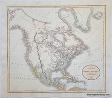
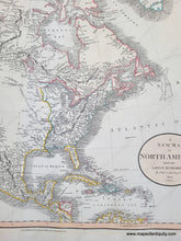
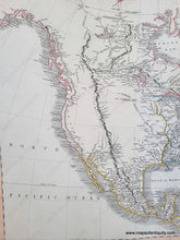
Antique engraved map of North America, with original color. Includes part of Greenland, Iceland, Mexico, Central America, Cuba and the West Indies. This map shows the vast unknown that was the American West before the information from the Lewis and Clark expedition was publicized. Despite the limited knowledge of the time, the detail is excellent with some guesses at the topography, such as the course of the Missouri River. This map is in very good restored condition. It has been cleaned, deacidified, and backed. Measures approx. 18.25 x 20.5 inches to the neatline.


Item Number: CSMT121