c. 1875
Maker: Colton
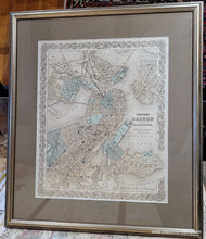
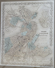
Antique hand colored map of Boston, Massachusetts, published by Colton, c. 1875. Includes the Back Bay area before the fill was complete but with lightly rendered streets that indicate the plan was in the works, Charlestown, East Boston, South Boston, Roxbury, East Cambridge, and parts of Somerville. In 1814, the Boston and Roxbury Mill Corporation was chartered to construct a milldam, which would also serve as a toll road connecting Boston to Watertown, bypassing Boston Neck. The dam prevented the natural tides from flushing sewage out to sea, creating severe sanitary and odor problems. With costs higher and power lower than expected, in the end, the project was an economic failure, and in 1857 a massive project was begun to "make land" by filling the area enclosed by the dam. Present-day Back Bay itself was filled by 1882; the project reached existing land at what is now Kenmore Square in 1890, and finished in the Fens in 1900. Shows outline of city blocks, names of major streets, railroads, and points of interest. Good to very good overall antique condition with some mild toning throughout, very mild foxing, and faded color. Framed. Framing appears to be archival. Measures approximately 14.5" x 11.75" to the neatline. Overall dimensions including frame are approx. 23 x 20 inches. Additional cost to ship framed map may be required- if you would like to know the total cost of shipping please contact us. Can be shipped unframed for lower shipping cost (map price remains the same).
Item Number: CSMT064


