Winter hours: Tuesday - Saturday 10am to 5pm. Close Sundays and Mondays until May. We appreciate your business!

Antique-Hand-Colored-Map-Map-of-the-United-States-and-Territories.-Together-with-Canada-etc.--United-States-United-States-General---1862-Mitchell-Maps-Of-Antiquity
  • Load image into Gallery viewer, Antique-Hand-Colored-Map-Map-of-the-United-States-and-Territories.-Together-with-Canada-etc.--United-States-United-States-General---1862-Mitchell-Maps-Of-Antiquity
  • Load image into Gallery viewer, Antique-Hand-Colored-Map-Map-of-the-United-States-and-Territories.-Together-with-Canada-etc.--United-States-United-States-General---1862-Mitchell-Maps-Of-Antiquity
  • Load image into Gallery viewer, Antique-Hand-Colored-Map-Map-of-the-United-States-and-Territories.-Together-with-Canada-etc.--United-States-United-States-General---1862-Mitchell-Maps-Of-Antiquity
  • Load image into Gallery viewer, Antique-Hand-Colored-Map-Map-of-the-United-States-and-Territories.-Together-with-Canada-etc.--United-States-United-States-General---1862-Mitchell-Maps-Of-Antiquity

1862 - Map of the United States and Territories. Together with Canada, etc. - Antique Map

Regular price
$350.00
Sale price
$350.00
Regular price
Sold out
Unit price
per 
Shipping calculated at checkout.

Item number: USA041
Genuine Antique Hand Colored Map

1862

Maker: Mitchell.


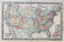
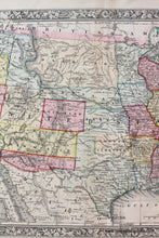
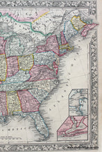
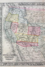
Antique hand colored map of the United States, with states and territories delineated by color, and with insets of Pensacola Bay and Hampton Roads and Norfolk Harbor. This map was published in 1862, during the Civil War. With detail of cities and towns, water bodies, and roads. Shows routes of Pony Express, and mail route to the west. Of particular interest: The government had been dividing the west into territories but halted doing so when it became clear that there was a divide between north and south- they did not want to create more states that would choose the Confederacy- so Dacotah is a large territory that encompasses modern Montana, Wyoming, both Dakotas, and Idaho. Washington territory has much of modern Idaho, Nevada is smaller, Utah is larger, and New Mexico and Arizona are shown as horizontal, which they never were except according to the settlers in the early 1860s- when the US government separated Arizona from New Mexico in 1863 they were divided vertically. Good to very good condition with slight seam separation at top and bottom center fold (archivally repaired), and some other minor signs of age including a small tear at bottom and some small spots in the margin. Measures approx. 13.25 x 21.5 inches.


Item Number: USA041