Hand-colored-Antique-Map-Washington-Co.-Belfast-Alfred-Kennebunk-Maine-United-States-Maine-c.-1884-Stuart/Colby-Maps-Of-Antiquity
Hand-colored-Antique-Map-Washington-Co.-Belfast-Alfred-Kennebunk-Eastport-Machias-Maine-United-States-Maine-c.-1884-Colby-Maps-Of-Antiquity
  • Load image into Gallery viewer, Hand-colored-Antique-Map-Washington-Co.-Belfast-Alfred-Kennebunk-Maine-United-States-Maine-c.-1884-Stuart/Colby-Maps-Of-Antiquity
  • Load image into Gallery viewer, Hand-colored-Antique-Map-Washington-Co.-Belfast-Alfred-Kennebunk-Maine-United-States-Maine-c.-1884-Stuart/Colby-Maps-Of-Antiquity
  • Load image into Gallery viewer, Hand-colored-Antique-Map-Washington-Co.-Belfast-Alfred-Kennebunk-Eastport-Machias-Maine-United-States-Maine-c.-1884-Colby-Maps-Of-Antiquity

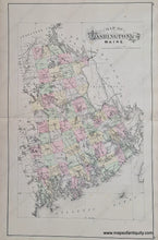
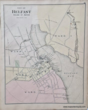
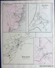
1884 - Double-sided sheet: Washington County, Maine; versos: City of Belfast; Eastport, Alfred, Machias, and Kennebunk, ME - Antique Map

Regular price
$115.00
Sale price
$115.00
Regular price
Sold out
Unit price
per 
Shipping calculated at checkout.

Item number: MAI096A
Hand-colored Genuine Antique Map

c. 1884

Maker: Colby.


Double-sided, hand-colored antique map of Washington County, Maine (centerfold) and the City of Belfast, and the towns of Eastport, Alfred, Machias, and Kennebunk on verso, including streets, factories and mills, property owners, businesses, churches, parks and cemeteries, very good condition, center spread measures approx. 24.5 x 15.5 inches, single sheet 15.5 x 12 inches.


Item Number: MAI096A