Current hours: 10am to 5pm Monday through Saturday. 12pm to 5pm Sundays. We are CLOSED on Christmas Day and New Years Day. We will close early (3pm) on Christmas Eve. IMPORTANT PLEASE NOTE: We have become aware that some of our photos have been stolen by other websites. Our maps are only available at our website www.mapsofantiquity.com or at our store!

Antique-Printed-Color-Pictorial-Map-State-of-Rhode-Island-1936-Phillips-Booth-Northeast-Rhode-Island-20th-century-Maps-of-Antiquity
1939 - State Of Rhode Island Antique Pictorial Map Genuine Printed-Color
  • Load image into Gallery viewer, Antique-Printed-Color-Pictorial-Map-State-of-Rhode-Island-1936-Phillips-Booth-Northeast-Rhode-Island-20th-century-Maps-of-Antiquity
  • Load image into Gallery viewer, 1939 - State Of Rhode Island Antique Pictorial Map Genuine Printed-Color

1939 - State of Rhode Island - Antique Pictorial Map

Regular price
$150.00
Sale price
$150.00
Regular price
Sold out
Unit price
per 
Shipping calculated at checkout.

Item number: RHO172
Genuine Antique Printed-Color Pictorial Map

1939

Maker: Phillips Booth.


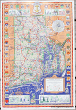
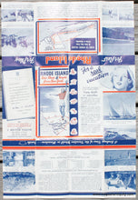
Antique pictorial map of Rhode Island made by Phillips D. Booth in 1936, this edition copyrighted 1939 but may have been printed later, possibly 1950s based on the way the woman on the verso is dressed. This map features a border with town seals, illustrations of historic buildings, notable sites marked on the map, major roads, a variety of ships, and more. The image of Roger Williams, founder of Providence, notes that this map was made for Rhode Island's Tercentenary. With folds as issued. Overall very good antique condition with some mild wear along the fold lines. Approx. 20.5 x 14 inches to the neatline. 


Item Number: RHO172