Current hours: 10:30am to 5pm Tuesday through Saturday. We are closed Sundays and Mondays for the Winter. IMPORTANT PLEASE NOTE: We have become aware that some of our photos have been stolen by other websites. Our maps are only available at our website www.mapsofantiquity.com or at our store!

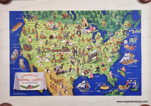
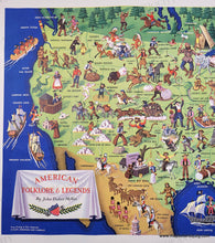
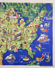
VIntage 1950s map in vibrant color with numerous illustrations of folktales and legends throughout. Bright blue ocean, green land, trees, ships, well known characters like Johnny Appleseed and Paul Bunyan. Antique-Printed-Color-Map-American-Folklore-&-Legends-c.-1950-John-Dukes-McKee-1900s-20th-century-Maps-of-Antiquity
1950 - American Folklore & Legends - Antique Pictorial Map
  • Load image into Gallery viewer, VIntage 1950s map in vibrant color with numerous illustrations of folktales and legends throughout. Bright blue ocean, green land, trees, ships, well known characters like Johnny Appleseed and Paul Bunyan. Antique-Printed-Color-Map-American-Folklore-&-Legends-c.-1950-John-Dukes-McKee-1900s-20th-century-Maps-of-Antiquity
  • Load image into Gallery viewer, 1950 - American Folklore & Legends - Antique Pictorial Map
  • Load image into Gallery viewer, 1950 - American Folklore & Legends - Antique Pictorial Map

1950 - American Folklore & Legends - Antique Pictorial Map

Regular price
$200.00
Sale price
$200.00
Regular price
Sold out
Unit price
per 
Shipping calculated at checkout.
 More payment options

Pickup available at 1409 MAIN ST, CHATHAM MA

Usually ready in 24 hours

Item number: CSMT205

Genuine Antique Printed Color Map

c. 1950

Maker: John Dukes McKee.


Genuine pictorial map of the United States by John Dukes McKee from Living in Our America, copyright Scott, Foresman and Company, c. 1950. This map features illustrations for real events in US history as well as the legends of fictional characters. Vibrant color brings the interesting, informative, and humorous illustrations to life. Some of the illustrations are likely considered politically incorrect in our modern era. Good to very good condition with horizontal wrinkles that are difficult to see except on close inspection (look near Bowleg Bill and across to Spanish Galleon), and some tears at the paper edges. Approx. 20 x 30.75 inches to the edges of the printed area.

Genuine Original Map from 1950s.

Item Number: CSMT205