Genuine Original Map
1970
Maker: Reproduction.
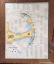
Original 1970 map of Cape Cod in vintage frame. Includes surrounding references listing shipwrecks, the type of ships, and the years in which they sank. These are categorized by the places where the shipwrecks took place. Map was created using material compiled by B. W. Luther, and calligraphy by Susan Doucette, and was published by Peter J. Closson, 1970. Good overall condition with a water stain at bottom and some mild waviness of the lightweight paper. Measures approximately 26.5" x 20.5" to the neatline (H x W.) Total size with the frame is approx. 31.5 x 25.5 inches. Best for in-store pick up due to size and weight. Would benefit from being re-framed with UV protective glass.
Genuine Vintage Map from 1970
Item Number: CSMT294


