1933
Maker: Courtland Smith.
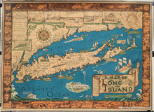
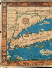
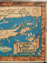
Unusual, playful tourist map of Long Island, drawn by Courtland Smith, compiled by Richard Foster, published by the Billboard Barn, dated 1933. Towns, parks, light houses and illustrations of key tourist sites are featured. Vibrant original color. Includes Brooklyn and Queens, the Hamptons, Montauk, and more. Landmarks such as Montauk Lighthouse, the beach at Southampton, and the Fire Island Light are depicted as illustrations. Additional delightful illustrations populate the Atlantic Ocean and Long Island Sound. The border is filled at the top with underwater scenes; on the sides with famous sites such as Birthplace of John Howard Payne, East Hampton, and Jones Beach; and with historical events, such as the settlement of Brooklyn and building of Brooklyn Bridge. The lower left of the border shows a scene of potato farming with the simple caption "Potatoes". The key indicates radio stations, state parks, ferry lines, small light houses, and mainland. Vivid color on heavy paper. Overall good to very good antique condition, with some damage at the paper edges (some of which has been archivally repaired, the other small tears will be repaired before shipping), and some minor stains in the decorative border on the left side that are barely noticeable. Some minor wrinkling. Measures about 27 x 20 inches.
Item Number: NYO384


