Antique-Printed-Color-Tourist-Map-A-Map-of-Mount-Desert-Island-and-Acadia-National-Park-Maine-1950-Robert-W.-Patterson-Chambers-of-Commerce-of-Bar-Harbor-Mount-Desert-and-Southwest-Harbor-Maine-1800s-19th-century-Maps-of-Antiquity
1950 - A Map of Mount Desert Island and Acadia National Park, Maine - Antique Map
  • Load image into Gallery viewer, Antique-Printed-Color-Tourist-Map-A-Map-of-Mount-Desert-Island-and-Acadia-National-Park-Maine-1950-Robert-W.-Patterson-Chambers-of-Commerce-of-Bar-Harbor-Mount-Desert-and-Southwest-Harbor-Maine-1800s-19th-century-Maps-of-Antiquity
  • Load image into Gallery viewer, 1950 - A Map of Mount Desert Island and Acadia National Park, Maine - Antique Map

1950 - A Map of Mount Desert Island and Acadia National Park, Maine - Antique Map

Regular price
$75.00
Sale price
$75.00
Regular price
Sold out
Unit price
per 
Shipping calculated at checkout.

Item number: MAI267
Genuine Antique Printed Color Tourist Map

1950

Maker: Robert W. Patterson / Chambers of Commerce of Bar Harbor, Mount Desert and Southwest Harbor.

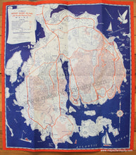
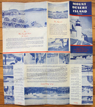
Antique printed color folding map of Mount Desert Island in Maine, published in 1950 by the Chambers of Commerce of Bar Harbor, Mount Desert and Southwest Harbor. Includes main highways, other roads, golf courses, points of interest, the area of the National Park, some topography, and more. This map was published as a travel pamphlet and the verso includes text and images relating to the island, the park, and the history of the area. Very good condition with some slight wear to the paper edges. Approx. 18 x 16 inches to the paper edges.

Item Number: MAI267