Winter hours: Tuesday - Saturday 10am to 5pm. Close Sundays and Mondays until May. We appreciate your business!

Antique-Printed-Color-Pictorial-Folding-Map-A-Map-of-the-Town-of-Northampton-Mass.-1934-Priscilla-Paine-Massachusetts-Northampton-1800s-19th-century-Maps-of-Antiquity
1934 - A Map of the Town of Northampton, Mass. - Antique Pictorial Map
  • Load image into Gallery viewer, Antique-Printed-Color-Pictorial-Folding-Map-A-Map-of-the-Town-of-Northampton-Mass.-1934-Priscilla-Paine-Massachusetts-Northampton-1800s-19th-century-Maps-of-Antiquity
  • Load image into Gallery viewer, 1934 - A Map of the Town of Northampton, Mass. - Antique Pictorial Map

1934 - A Map of the Town of Northampton, Mass. - Antique Pictorial Map

Regular price
$425.00
Sale price
$425.00
Regular price
Sold out
Unit price
per 
Shipping calculated at checkout.

Item number: TOW580
Genuine Antique Printed Color Pictorial Folding Map

1934

Maker: Priscilla Paine.

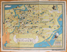
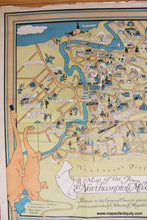
Antique printed color pictorial map of Northampton, Massachusetts, designed by Priscilla Paine, and published by the Hampshire Bookshop in Northampton, 1934. Features illustrations of notable buildings, points of interest, and historical events with humorous captions and historic quotes. Includes the names of major roads and bodies of water. With folds, as issued. Good overall antique condition with mild toning and wrinkling. Some damage at the paper edges, but that can be hidden under a mat; it should frame wonderfully. Measures approximately 23" x 30" (H x W) to the outer edges of the decorative border.

Item Number: TOW580