Current hours: 10am to 5pm Monday through Saturday. 12pm to 5pm Sundays. We are CLOSED on Christmas Day and New Years Day. We will close early (3pm) on Christmas Eve. IMPORTANT PLEASE NOTE: We have become aware that some of our photos have been stolen by other websites. Our maps are only available at our website www.mapsofantiquity.com or at our store!

Antique-Printed-Color-Map-Alaska-Far-North-Frontier-1959-R.-Klengston-Rude-West-1900s-20th-century-Maps-of-Antiquity
1959 - Alaska Far North Frontier Antique Map Genuine Printed-Color
  • Load image into Gallery viewer, Antique-Printed-Color-Map-Alaska-Far-North-Frontier-1959-R.-Klengston-Rude-West-1900s-20th-century-Maps-of-Antiquity
  • Load image into Gallery viewer, 1959 - Alaska Far North Frontier Antique Map Genuine Printed-Color

1959 - Alaska Far North Frontier - Antique Map

Regular price
$225.00
Sale price
$225.00
Regular price
Sold out
Unit price
per 
Shipping calculated at checkout.

Item number: WES358
Genuine Antique Printed Color Map

1959

Maker: R. Klengston Rude.

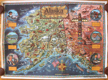
Printed color pictorial map of Alaska created by R. Klengston Rude in 1959, the year Alaska was granted statehood. This vibrant map features delightful illustrations of a variety of animals, birds, people, boats, planes, trains and circular vignettes illustrating Alaska's major historical events. 1. 1741 Vitus Bering responsible for discovering Alaska 2. 1784 first settlement by Russians on Kodiak Island 1867 3. U.S. purchases Alaska from Russia (known as Seward's Folly) 4. 1897 gold is discovered in Alaska 5. 1900 Juneau made territorial capital 6. 1959 President Eisenhower signs official proclamation making Alaska 49th state. Good condition with some creasing/wrinkles that go horizontally across the map but are not very noticeable because of the bright colors. Some slight toning at the edges of the paper. Approx. 33 x 44.5 inches to the paper edges.

Item Number: WES358