Winter hours: Tuesday - Saturday 10am to 5pm. Close Sundays and Mondays until May. We appreciate your business!

Antique-Printed-Color-Pictorial-Map-Animated-Map-of-Prince-Edward-Island-North-America-Canada-1940s-Arthur-Edward-Elias-Maps-Of-Antiquity
1929 - Animated Map of Prince Edward Island - Antique Pictorial Map
  • Load image into Gallery viewer, Antique-Printed-Color-Pictorial-Map-Animated-Map-of-Prince-Edward-Island-North-America-Canada-1940s-Arthur-Edward-Elias-Maps-Of-Antiquity
  • Load image into Gallery viewer, 1929 - Animated Map of Prince Edward Island - Antique Pictorial Map

1929 - Animated Map of Prince Edward Island - Antique Pictorial Map

Regular price
$125.00
Sale price
$125.00
Regular price
Sold out
Unit price
per 
Shipping calculated at checkout.

Item number: CAN227
Genuine Antique Printed Color Pictorial Map

c. 1929

Maker: Arthur Edward Elias.


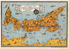
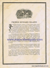
Antique printed color map featuring the province of Prince Edward Island, Canada. Undated but many professionals seem to agree that it is from 1929 (see David Rumsey Map Collection, part of Stanford).  The artist uses a pictorial style showing some of the good sport of the area with some humor. The map features images of sportsmen, bear, moose, and more, with railroads and cities including Charlottetown, Cardigan, and Summerside. Includes a separate sheet that describes the natural resources of the area. Very good antique condition with some minor wear to pages, minor water stain at lower right corner, also some possible minor spots. approx. 9.75 x 14 inches to neatline.


Item Number: CAN227