Antique-Printed-Color-Map-Asia-verso:-Ceylon-and-Turkish-Empire-in-Europe-and-Asia-Asia-Asia-Ceylon-Turkish-Empire-1894-Cram-Maps-Of-Antiquity
1894 - Asia, verso: Ceylon and Turkish Empire in Europe and Asia - Antique Map
  • Load image into Gallery viewer, Antique-Printed-Color-Map-Asia-verso:-Ceylon-and-Turkish-Empire-in-Europe-and-Asia-Asia-Asia-Ceylon-Turkish-Empire-1894-Cram-Maps-Of-Antiquity
  • Load image into Gallery viewer, 1894 - Asia, verso: Ceylon and Turkish Empire in Europe and Asia - Antique Map
  • Load image into Gallery viewer, 1894 - Asia, verso: Ceylon and Turkish Empire in Europe and Asia - Antique Map

1894 - Asia, verso: Ceylon and Turkish Empire in Europe and Asia - Antique Map

Regular price
$60.00
Sale price
$60.00
Regular price
Sold out
Unit price
per 
Shipping calculated at checkout.

Item number: ASI316
Genuine Antique Printed Color Map

1894

Maker: Cram.

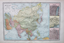
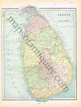
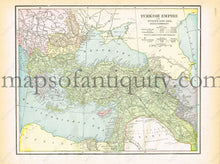
Antique printed color map of Asia (recto map, double-page spread, 298 & 299) Featuring 3 large insets of Jerusalem, Canton and Delhi. Verso: Map of Ceylon (present-day Sri Lanka) showing the major provinces (page 297). Verso: Map of the Turkish Empire both in Europe and Asia (page 300) Very good condition with some slight toning at the edges. By Cram, in The Standard Atlas and Gazetteer of The World, 1894. Recto Map: Approximately 11.5" x 17.5" to the neatline. Verso Map left: Approx. 12.75" x 9.75" Extends over the top and bottom borders. Verso Map right: Approx. 9.5" x 12" to the neatline.

Item Number: ASI316