Winter hours: Tuesday - Saturday 10am to 5pm. Close Sundays and Mondays until May. We appreciate your business!

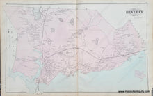
Antique-Hand-Colored-Map-Beverly-Mass.--**********-Massachusetts--1884-Walker-Maps-Of-Antiquity
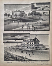
engravings of Clifton House in Marblehead and the Hotel Nahant
  • Load image into Gallery viewer, Antique-Hand-Colored-Map-Beverly-Mass.--**********-Massachusetts--1884-Walker-Maps-Of-Antiquity
  • Load image into Gallery viewer, engravings of Clifton House in Marblehead and the Hotel Nahant

1884 - Beverly, Mass. - Antique Map

Regular price
$150.00
Sale price
$150.00
Regular price
Sold out
Unit price
per 
Shipping calculated at checkout.

Item number: MAS1488
Genuine Antique Hand-Colored Map

1884

Maker: Walker.


Antique, hand-colored map of Beverly, MA, from Walker's 1884 atlas of Essex County, showing property owners and key buildings, railroads, villages of Beverly Farms, Centreville, North Beverly, Beverly Cove, West Farms, and Beverly center, verso displays engravings of Clifton House in Marblehead and the Hotel Nahant. Very good condition with minor toning, slight darkening at center fold long glue strip, some minor paper loss at lower right that can be hidden with a mat when framing. Measures approx. 16 x 25.75 inches 


Item Number: MAS1488