1938
Maker: Bromley
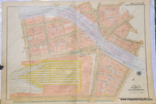
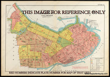
Antique map of part of Boston from the Atlas of the City of Boston, Boston Proper and Back Bay, by G.W. Bromley & Co. 1938. This map includes South Station, with a pasted-on addition for the Fitzgerald Expressway. The first plans for an elevated roadway were developed by the city of Boston in 1930 and it was completed in 1959. Also called the Central Artery, it has since been partially replaced by the Big Dig tunnel. With property owners names and vibrant original printed color to indicate the types of buildings for tax and insurance purposes (pink is brick, brown is stone, yellow is frame or wood, and blue is iron). Fair to good condition with wear at the edges of the paper, some mild staining, some wear along the fold. This map was backed on fabric after being printed, to make it sturdy. Should frame nicely and imperfections at edges can be hidden under a mat. Measures approx. 23 x 33 inches to the paper edges.
Item Number: BOS024


