Winter hours: Tuesday - Saturday 10am to 5pm. Close Sundays and Mondays until May. We appreciate your business!

Antique-Road-Map-West-California-Dist-O-Map-1969-Plumly-Mfg.-Corp-California-1900s-20th-century-Maps-of-Antiquity
1969 - California Dist-O-Map - Antique Map
  • Load image into Gallery viewer, Antique-Road-Map-West-California-Dist-O-Map-1969-Plumly-Mfg.-Corp-California-1900s-20th-century-Maps-of-Antiquity
  • Load image into Gallery viewer, 1969 - California Dist-O-Map - Antique Map

1969 - California Dist-O-Map - Antique Map

Regular price
$55.00
Sale price
$55.00
Regular price
Sold out
Unit price
per 
Shipping calculated at checkout.

Item number: WES394
Genuine Antique Road Map

1969

Maker: Plumly Mfg. Corp.

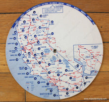
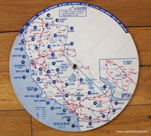
Antique printed color "Dist-O-Map" of California by Plumly Mfg. Corp., 1969. This interesting map consists of two layers of paperboard hinged at the center so that they can be rotated. The map is used by setting the arrow at top to the city nearest one's starting point, then the distance from starting point to destination can be read in the window of the destination and the principal highways between cities are in red. Very good condition with some minor wear and a small stain that does not affect the usefulness or reading of the map. Measures approx. 7.5 inches in diameter.

Item Number: WES394