1757
Maker: Bellin.
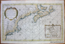
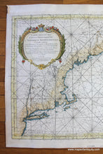
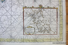
Antique hand colored map of the north eastern coast of North America, from Cape Breton Island to Long Island, by Bellin, 1757. Includes New York, Connecticut, Rhode Island, Massachusetts, New Hampshire, Vermont and the Province de Terre Main (Maine), as well as parts of Canada such as Nova Scotia, Prince Edward Island (Isle St Jean), and Cape Breton (Ile-Royale). Hundreds of place names, soundings, rivers, islands, shoals, banks, ports, bays, etc. Detailed inset of Boston Harbor. This is known as one of the best general New England coastal charts of the French & Indian War period. Unlike other examples on the market, our chart includes rhumb lines in the Boston inset. Age of the color is unknown. Remarkably good condition- we are not aware that this map has been restored and therefore we believe it to be in very good antique condition with minor signs of age, mostly at the paper edges. Measures approx. 21.5 x 34.5 inches to the neatline. **NOTE- because this map requires extra insurance for shipping, an additional charge will appear on your card after your original purchase. If you would like to know what that charge will be, please contact us.**
Item Number: NAM264


