Current hours: 10am to 5pm Monday through Saturday. 12pm to 5pm Sundays. IMPORTANT PLEASE NOTE: We have become aware that some of our photos have been stolen by other websites. Our maps are only available at our website www.mapsofantiquity.com or at our store!

Antique-Military-Lithographed-Map-Celebes-Netherlands-Indies-Indonesia-/-WWII-Newsmap-Military-World-War-II-1944-U.S.-Government-Maps-Of-Antiquity
1944 - Celebes, Netherlands Indies, Indonesia / WWII Newsmap - Antique Map
  • Load image into Gallery viewer, Antique-Military-Lithographed-Map-Celebes-Netherlands-Indies-Indonesia-/-WWII-Newsmap-Military-World-War-II-1944-U.S.-Government-Maps-Of-Antiquity
  • Load image into Gallery viewer, 1944 - Celebes, Netherlands Indies, Indonesia / WWII Newsmap - Antique Map
  • Load image into Gallery viewer, 1944 - Celebes, Netherlands Indies, Indonesia / WWII Newsmap - Antique Map

1944 - Celebes, Netherlands Indies, Indonesia / WWII Newsmap - Antique Map

Regular price
$250.00
Sale price
$250.00
Regular price
Sold out
Unit price
per 
Shipping calculated at checkout.

Item number: MIL001DS
Genuine Antique Military Lithographed Map

1944

Maker: U.S. Government.

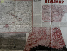
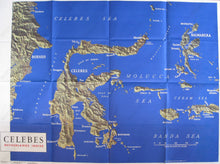
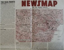
This colorful WWII Newsmap was printed for the week of 23 August to 30 August, volume III, No. 20B. Prepared and distributed by the Army information Branch, Navy distribution by the Educational Service Section of the Navy Department. The Newsmap side includes Southern France looking North up the Rhone River Valley, an aerial view of one of the ports in Southern Italy just before the landing on Southern France, and reports on the War Fronts in North France, South France, Italy, the Pacific and Eastern Fronts. Reverse of paper is a large relief map of "Celebes" or Indonesia. This map is measures approximately 35 x 47 inches. It is permanently creased where it was originally folded, and is in otherwise Very good overall antique condition.

Item Number: MIL001DS