Current hours: 10am to 5pm Monday through Saturday. 12pm to 5pm Sundays. IMPORTANT PLEASE NOTE: We have become aware that some of our photos have been stolen by other websites. Our maps are only available at our website www.mapsofantiquity.com or at our store!

Antique-Hand-Colored-Map-China-Veteribus-Sinarum-Regio-nunc-Incolis-Tame-dicta-Asia-China-c.-1636-Jansson-Maps-Of-Antiquity-1800s-19th-century
1636 - China Veteribus Sinarum Regio Nunc Incolis Tame Dicta Antique Map Genuine
  • Load image into Gallery viewer, Antique-Hand-Colored-Map-China-Veteribus-Sinarum-Regio-nunc-Incolis-Tame-dicta-Asia-China-c.-1636-Jansson-Maps-Of-Antiquity-1800s-19th-century
  • Load image into Gallery viewer, 1636 - China Veteribus Sinarum Regio Nunc Incolis Tame Dicta Antique Map Genuine
  • Load image into Gallery viewer, 1636 - China Veteribus Sinarum Regio Nunc Incolis Tame Dicta Antique Map Genuine

1636 - China Veteribus Sinarum Regio nunc Incolis Tame dicta - Antique Map

Regular price
$1,100.00
Sale price
$1,100.00
Regular price
Sold out
Unit price
per 
Shipping calculated at checkout.

Item number: CSMT052JD
Genuine Antique Map

c. 1636

Maker: Jansson.

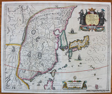
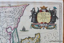
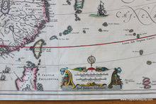
Antique hand colored map of China from the Novus Atlas by Jansson, c. 1636. Includes China bound in the northwest by the Great Wall, Korea as an island, Japan, Taiwan, and more. In the far west of the map is Chiamay Lacus, an imaginary lake with many rivers flowing south into India and Siam. Ships are both European and Chinese styes. Beautifully decorative cartouche and scale of miles. This map has been archivally restored- cleaned, deacidified, and tears in the lower center of the map repaired. Measures approx. 16 x 19.5 inches to the neatline.

Item Number: CSMT052JD