Current hours: 10am to 5pm Monday through Saturday. 12pm to 5pm Sundays. We are CLOSED on Christmas Day and New Years Day. We will close early (3pm) on Christmas Eve. IMPORTANT PLEASE NOTE: We have become aware that some of our photos have been stolen by other websites. Our maps are only available at our website www.mapsofantiquity.com or at our store!

Antique-Pictorial-Chart-Coastwise-Cruising-Guide-Kennebunkport-ME.-to-Fall-River-MA.-1940s-Socony-Vacuum-Oil-/-Rand-McNally---1800s-19th-century-Maps-of-Antiquity
1940S - Coastwise Cruising Guide Kennebunkport Me. To Fall River Ma. Antique Pictorial Map Genuine
  • Load image into Gallery viewer, Antique-Pictorial-Chart-Coastwise-Cruising-Guide-Kennebunkport-ME.-to-Fall-River-MA.-1940s-Socony-Vacuum-Oil-/-Rand-McNally---1800s-19th-century-Maps-of-Antiquity
  • Load image into Gallery viewer, 1940S - Coastwise Cruising Guide Kennebunkport Me. To Fall River Ma. Antique Pictorial Map Genuine
  • Load image into Gallery viewer, 1940S - Coastwise Cruising Guide Kennebunkport Me. To Fall River Ma. Antique Pictorial Map Genuine
  • Load image into Gallery viewer, 1940S - Coastwise Cruising Guide Kennebunkport Me. To Fall River Ma. Antique Pictorial Map Genuine

1940s - Coastwise Cruising Guide Kennebunkport, ME. to Fall River, MA. - Antique Pictorial Map

Regular price
$125.00
Sale price
$125.00
Regular price
Sold out
Unit price
per 
Shipping calculated at checkout.

Item number: NAU375
Genuine Antique Pictorial Chart

1940s

Maker: Socony-Vacuum Oil / Rand McNally.

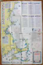
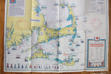
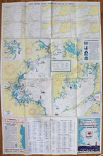
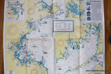
Antique pictorial nautical chart produced by Socony-Vacuum Oil Company, Inc. and General Drafting Co., c. 1940s. This double-sided folding chart shows the coast from Kennebunkport, Maine to Fall River, Massachusetts and Narragansett Bay, including Cape Cod, Nantucket, Martha's Vineyard, Boston, Plymouth, Cape Ann, and Portsmouth. Includes navigational information such as storm signals, bouy meanings, international code, water depths, distances, and lighthouse and lightship locations. Descriptions of the major navigational areas for the beginning sailor fill the upper right. With colored illustrations of the lighthouses and lightships and uncolored illustrations of notable buildings and landmarks. Verso offers many charts showing general strength and direction of currents in various areas, as well as a close view of Boston Harbor, Buzzards Bay, Portsmouth Harbor, and Lake Winnipesaukee. Very good condition with folds as issued and some wear and toning along the folds. Measures approx. 38 x 25 inches to the paper edges.

Item Number: NAU375