Antique-Map-Comparative-Charts-of-Population-Railroads-Telegraph-Lines-Comparative-Maps--1888-Tunison-Maps-Of-Antiquity-1800s-19th-century

1888 - Comparative Charts of Population, Railroads, Telegraph Lines *****SOLD***** - Antique Map

Regular price
$40.00
Sale price
$40.00
Regular price
Sold out
Unit price
per 
Shipping calculated at checkout.

Item number: COM046
Genuine Antique Map

1888

Maker: Tunison.

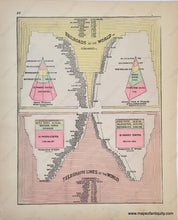
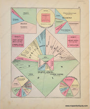
Antique double-sided sheet from Tunison's Peerless Universal Atlas of the World, c. 1888 by H.C. Tunison. On one side are various comparative charts relating to population, on the other side are charts comparing Railroads of the World and Telegraph Lines of the World. Vibrant original color. Fair to good antique condition with some minor stains and smudges (moreso on the population chart side), and some small wrinkles. The strike on some pages in this atlas is a bit faint. Measures approx. 14 x 11 inches to the paper edges. **SOLD**

Item Number: COM046