1760s
Maker: Vaugondy
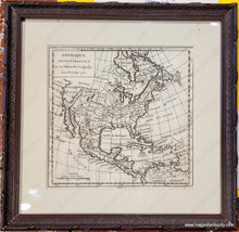
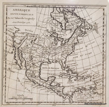
Antique map of North America by le Sr. Robert de Vaugondy, c. 1760. This map has a printed date of 1750 but it continued to be used in later atlases with the same date. One way to tell the age of the map is by the page number, but the framer hid the page number under the mat when framing the map. If it is page 482, then it is likely from 1750, but any other page number indicates that it is a later printing. The map features North America with early and interesting information. It includes Long Island, Boston, and Cape Cod, although the shape of the land in that area is very rudimentary. The St Lawrence River and Great Lakes are represented in a way that suggests easy passage of ships. Florida's shape is a bit different and the Appalachian Mountains run down the middle of it. The French claimed area at the center of the continent is labeled "Floride ou Louisiane" and many Native American Indian areas are noted. Baja California is prominent and north of it is a largely blank area labeled Quivira (the legendary city of gold). This small map contains plenty of delightful and interesting details, including the spelling of Virginia as Wirginnie, and it will surely reward time spent studying and enjoying it. With folds as issued. Very good condition, framed. Framing appears to be archival. Map measures approx. 6 x 6 inches to the neatline and 9.5 x 9.5 inches to the outer frame edges.
Item Number: CSMT066


