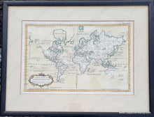
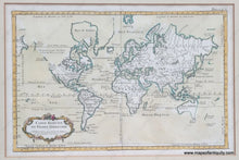
1764
Maker: Bellin
Antique map of the world by Jacques Nicolas Bellin, c. 1764. From 'Le Petit Atlas Maritime Recueti de Cartes et Plans des Quatre Parlies du Monde en Cinq Volumes', first published in 1764, just before Captain Cook's voyages that provided significant advances in geographical understanding of the Pacific. On this map Tasmania is attached to Australia and little is known of New Zealand. The North West of North America is unknown, with only a few notes and the apocryphal Sea of the West. Nothing is shown of Antarctica. The Great Lakes are recognizable, but have been joined by some other fanciful lakes. A beautiful and fascinating map with many interesting features to explore. Framed- mat board is not archival and should be changed. Otherwise frame is in good condition. Map is in very good condition with some minor tiny spots. It may have discoloration under the matboard. Center fold as issued. Map measures approx. 8.75 x 13.5 inches to the neatline. Total dimensions including frame 15 x 19.5. Can be shipped without frame, which will reduce the cost of shipping, but map price remains the same.
Item Number: CSMT104


