1784
Maker: Bowles
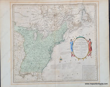
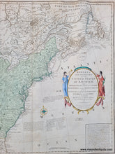
Full Title: Bowles's New Pocket Map of the United States of America; the British Possessions of Canada, Nova Scotia, and Newfoundland with the French and Spanish Territories of Louisiana and Florida, as Settled by The Preliminary Articles of Peace, Signed at Versailles the 20th Jan.y. 1783
Antique map of the United States by Carington Bowles, published in 1784. This rare and desirable collector's map shows the country at a pivotal time, when France claimed the land of Louisiana west of the Mississippi, Spain held East and West Florida, and Britain had solidified it's hold of Canada. Thirteen states are named with interesting boundaries. Maine is part of New Hampshire and Vermont is part of New York. The western part of the United States is labeled Reserved Country. Many groups of Native American Indians are noted throughout. Gentlewomen in bright gowns flank the title cartouche. Spelling of place names is phonetic and unusual. Text explains the fishing rights according to various agreements. Newfoundland was colored half blue and half yellow because, after the Treaty of Paris, France had fishing rights on the western coast although the land belonged to Britain. Map is in good to very good condition with some light foxing and minor discoloration outside the neatline from an old matboard. Slight creases at top from past framing. Center fold as issued. Could be restored for an additional cost. Map measures approx. 18.5 x 20 inches to the mat opening. Shipping this map with full insurance will cost more. Please contact us if you would like it shipped with less insurance to reduce the cost of shipping.
Item Number: CSMT106


